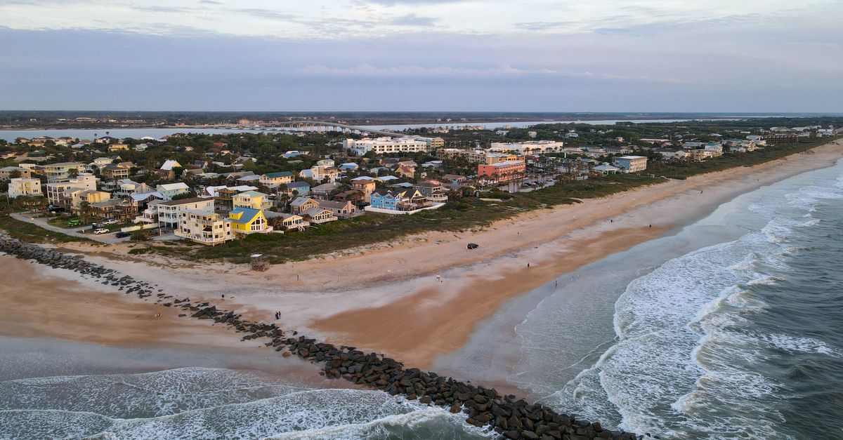
Amelia Island has one continuous Atlantic beach that runs roughly 13 miles down its eastern shore, reached by dozens of public access points and bookended by two state parks: Fort Clinch at the north tip and Amelia Island State Park at the south. The sand is firm tan quartz, the tide swings about six feet, and you can walk from a brick fort to a horseback ride on the south end without ever leaving the same strip of beach.
Most visitors picture a single "Amelia Island beach." There isn't one. There's a long shoreline with a different personality every mile or two, and the stretch you fall for usually says more about you than about the sand.
How many beaches are on Amelia Island?
One, and more than a dozen at the same time. The island has a single unbroken Atlantic beach about 13 miles long, but the public reaches it through more than a dozen named access points and a handful of full beach parks, each with its own parking, crowd, and feel. That is why locals talk about them as separate beaches even though the sand never stops.
Here are the major ones, north to south:
| Beach park | Where | Best for |
|---|---|---|
| Fort Clinch State Park | North tip | Wild dunes, fishing pier, shark teeth, the old fort |
| Main Beach | North-central, end of Atlantic Ave | Families, volleyball, food, seasonal lifeguards |
| Seaside Park | Central | A quick swim, restrooms, a smaller lot |
| Peters Point Beachfront Park | South-central | Wide sand, boardwalks, picnic shelters |
| Burney Park (American Beach) | South | Quieter sand, local history |
| Amelia Island State Park | South tip | Horseback riding, undeveloped sand, fishing at the sound |
Between those, you'll find scores of numbered street-end accesses with little more than a boardwalk and a few parking spots. Those are where residents actually go. No sign, no crowd, just a path through the sea oats.
What's the difference between Fernandina Beach and Amelia Island?
Amelia Island is the 13-mile barrier island; Fernandina Beach is the only city on it, sitting at the north end. People use the two names for the same vacation, but only the northern third of the island is inside city limits. The south end, where the big golf resorts sit, is unincorporated Nassau County. The in-town public beach is even named Main Beach, at the foot of Atlantic Avenue, a few minutes from the downtown shrimp docks.
So if someone says they're "going to Fernandina," they usually mean the historic downtown and the northern beaches. "Amelia Island" tends to cover the whole island, resorts included. The barrier island sits at the northeastern corner of Florida, just across the St. Marys River from Georgia, with Cumberland Island visible across the water to the north.
One thing the names hide: Fernandina is a working shrimping town, not only a beach. The boats still go out, and on an east wind you can smell the marsh behind the dunes.
What is the most beautiful beach on Amelia Island?
Fort Clinch State Park, at the north tip, is the most beautiful stretch for my money. The sand is wide and dune-backed, the crowds thin out fast, and a brick fort begun in the 1840s sits behind you while Cumberland Island floats across the sound. The park is also the island's best spot to hunt fossilized shark teeth, especially after a winter blow churns the bottom.
If you'd trade amenities for solitude, the south end inside Amelia Island State Park is the other real contender. There the beach runs out to Nassau Sound with no condos in sight, just dunes, anglers, and the occasional horse. Drive a few minutes further south across the sound and you reach Big Talbot's Boneyard Beach, where storm-toppled live oaks bleach on the sand. That one isn't on Amelia proper, but it's close enough that locals count it.
Beauty here is seasonal, though. The same beach that glitters on a still October morning can turn flat and gray under a February northeast wind, with foam blowing down the sand like tumbleweed.
What is the nicest part of Amelia Island?
It depends on what you want from a beach day, so here's the honest split. For families and amenities, the north-central stretch around Main Beach and Seaside Park is the nicest, with food, a playground, volleyball nets, and lifeguards in summer. For wide, calm sand and boardwalks, Peters Point in the south-central is hard to beat. For wild and uncrowded, you want the two state parks at either tip.
The far south end, near the resorts, has the most dramatic dunes and the quietest sand, partly because public parking is thinner down there. The north end gives you the fort, the shrimp town, and the shortest walk to a restaurant after the beach. The middle is the everyday island, where most residents live and where the street-end accesses keep beach days cheap and unhurried.
When buyers ask us at Salt Harbor which part of the island is "best," the honest answer is to walk a few different access points before you decide. The dune-backed quiet of the south and the walk-to-downtown north are two different lives, and the beach you keep coming back to tends to settle the question for you.
A note on Burney Park, in the south: it sits in American Beach, a seaside community founded in 1935 by Abraham Lincoln Lewis and the Afro-American Life Insurance Company. NaNa, one of the largest dune systems on the island, rises behind it, and the small A.L. Lewis Museum nearby tells the community's history. The history is reason enough to stop.
What the beaches feel like through the year
Summer is peak season, with water around 80 to 85 degrees, afternoon thunderstorms that build over the marsh, and warm surf that holds into October. It's also sea turtle nesting season, May through October, when loggerheads (and a few greens) crawl up at night to lay. You'll see staked-off nests along the dune line and signs asking you to kill outdoor lights.
Fall is the locals' season. The water stays warm, the crowds thin, and the biting no-see-ums that haunt summer dawns and dusks finally ease off. Winter water drops into the 50s, too cold for most swimming, but the beach turns into prime walking and shelling ground, and the best shark-tooth hunting of the year. Right whales calve offshore between roughly December and February. Spring brings wind, pollen, and warming sand, the shoulder before the summer rush.
Whatever the season, mind the tide. With a swing of around six feet, low tide opens a broad hard flat that's perfect for biking or a long walk, while high tide can pin you against the dunes on the narrower stretches.
Parking, dogs, and the practical stuff
Most Amelia Island beach access is free, including the street-end boardwalks and Main Beach, though the two state parks charge a small per-vehicle entry fee. Leashed dogs are welcome on most of the island's beaches, which is part of why you'll see so many of them at sunrise. Pack water, because shade is scarce once you're past the dune line.
A few stretches still allow you to park on the sand at designated accesses, with seasonal closures during turtle nesting, so check the current Nassau County rules before you drive onto the beach. Glass is a no, and so is taking home anything alive: those whelk shells with a resident inside go back in the water. The sand gnats, sadly, are not optional gear; bring repellent if you're out near dawn or dusk in the warm months.
None of this is a ranking you have to settle. The point of 13 miles is that you don't have to pick. If you're weighing a move and want to know which access is a two-minute walk from which street, that's the kind of thing we map out at Salt Harbor before anyone signs anything. The beach is the easy part. Figuring out which version of it you want to wake up to is the rest.
Frequently asked questions
How many beaches are on Amelia Island?
Amelia Island has one continuous Atlantic beach about 13 miles long, reached by more than a dozen named public access points and a handful of full beach parks, from Fort Clinch State Park in the north to Amelia Island State Park at the south tip. Locals treat the access points as separate beaches because each has its own parking and crowd.
What's the difference between Fernandina Beach and Amelia Island?
Amelia Island is the 13-mile barrier island; Fernandina Beach is the only city on it, at the north end. The names are used interchangeably for the destination, but only the northern third is inside city limits, while the resort-heavy south end is unincorporated Nassau County.
What is the most beautiful beach on Amelia Island?
Fort Clinch State Park at the north tip is the most scenic, with wide dune-backed sand, a brick fort begun in the 1840s, and views of Cumberland Island across the sound. For undeveloped beauty over amenities, the south end inside Amelia Island State Park, where the beach meets Nassau Sound, is the other top pick.
What is the nicest part of Amelia Island?
It depends on the beach day you want. The north-central stretch around Main Beach and Seaside Park is best for families and amenities, Peters Point in the south-central offers wide sand and boardwalks, and the two state parks at either tip are best for wild, uncrowded sand.